BBC: German publishing giant releases maps showing occupied territories of Ukraine as "disputed territory"
These maps somehow legitimize Russia's encroachment on Ukrainian territories, experts say

The German media giant, map and atlas publisher MairDumont, supplies Western European bookstores with maps and guidebooks that mark Ukraine's internationally recognized borders as "disputed" with Russia.
Source. This is stated in the BBC investigation.
On the eve of the new school year, Ukrainian Nina, who left for Austria because of the war, decided to buy a geographical atlas for her 12-year-old son. But when she examined the purchase at home, she could not believe her eyes.
"I saw some dotted marks in the middle of Ukraine. At first I didn't understand what it was, and then I looked at the transcript, and it turned out that the east and south of Ukraine are disputed territories," says Nina.
"I was just in shock. I didn't even show the atlas to my son. How can I explain to him why our country is divided into parts in this book?" – she adds.
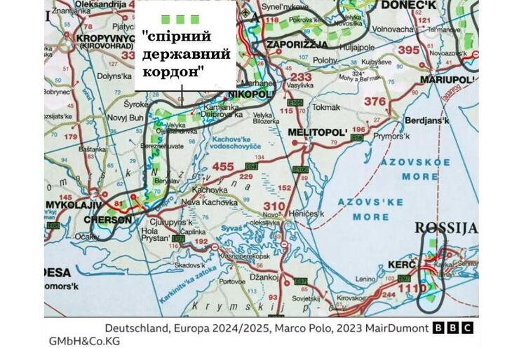
This atlas was published by the German publishing house Kunth in 2023. In it, five regions of Ukraine-Zaporizhzhia, Kherson, Donetsk, Luhansk, and Crimea-are marked with a dotted line as territories with a "disputed state border." The same dotted line marks the entire eastern border with Russia in the Donbas and Crimea.
The dotted line does not follow the line of hostilities, but rather the border of these regions, which have never been fully occupied.
These are the regions that the Kremlin illegally declared "Russian" in September 2022, in addition to Crimea.
Subsequently, Russia began to release maps showing all five regions of Ukraine as part of Russia. This included Ukrainian cities and villages that had never been under Russian occupation.
"I'm from Zaporizhzhia myself, it's a huge city. It was never occupied for a single day, there were no Russian soldiers there. But on Russian maps, it is in Russia, and on German maps, it is on 'disputed territory,'" Mykola Holubey, founder of the Stop Mapaganda project, is outraged, "Just like Kherson, which was liberated from the Russians in November 2022. It is also on these maps in the "disputed territory". In my opinion, this is the legalization of the so-called Russian "referendums" in the fall of 2022."
Mykola Holubey visited about 30 bookstores in Germany, Austria, and Switzerland and bought all the maps and guidebooks that, according to him, incorrectly depict the territory of Ukraine. Among the publishers of such products are not only the aforementioned Kunth, but also other German brands with a worldwide reputation, such as ADAC and Marco Polo, as well as the Swiss publishing house Kümmerly+Frey.
"I don't think I would have been so shocked if I had seen this on a map produced in Moscow," says Mykola, "but these are products of professional Western cartographers. I don't understand why this is happening in Europe."
The BBC found that all of the above-mentioned brands are part of the same group, MairDumont GmbH & Co. KG.
This German giant is the country's largest guidebook publishing group, headquartered in Ostfildern, near Stuttgart.
MairDumont includes more than a dozen companies. Among them are Hallwag Kümmerly+Frey, Switzerland's leading travel publisher, which is an independent subsidiary of MairDumont, and the well-known Marco Polo brand, one of the most popular guidebooks in Germany and throughout Europe.
Over 25 years, more than 100 million Marco Polo guidebooks have been sold. "One in four guidebooks bought in Germany is a Marco Polo," according to the official MairDumont website.
MairDumont products can be found on store shelves in Western Europe. Their maps and atlases are sold through the largest bookstore chains in Germany, Switzerland, and Austria, which include about 1000 stores. Their products are also available in bookstores in the UK.
"The label "disputed border" implies that there is some kind of dispute between the countries that needs to be resolved. But in this situation, there is no dispute! Since 1991, it has been quite clear that Ukraine has certain state borders," says Klaus Dodds, Professor of Geopolitics at King's College Galloway in London.
"So what do these maps do? They somehow legitimize Russia's encroachment on Ukrainian territory. That's why it's so dangerous. It's actually a reproduction of propaganda by third parties," adds the professor.
MairDumont declined to comment. Instead, they sent the BBC the text of an official statement that was previously sent to the Ukrainian embassies in Switzerland and Germany after a request from Ukrainian diplomats.
MairDumont notes that it recognizes all five regions as the territory of Ukraine, but uses a dotted line to indicate the de facto conflict zone. "We believe it is our responsibility to inform our clients of the current situation on the ground in the event of conflicts," the statement said.
But experts argue that if the company really intended to warn its readers about the potential danger, it should have depicted the entire territory of Ukraine as a war zone and added appropriate designations and decipherments. And this is not in the atlases.
If you have read this article to the end, we hope that means it was useful for you.
We work to ensure that our journalistic and analytical work is of high quality, and we strive to perform it as competently as possible. This also requires financial independence. Support us for only UAH 196 per month.
Become a Mind subscriber for just USD 5 per month and support the development of independent business journalism!
You can unsubscribe at any time in your LIQPAY account or by sending us an email: [email protected]


